Amazon Deforestation: How Illegal Mining Devastates Latin American Forests
The Amazon rainforest is the biggest natural carbon sink in the world. It provides a crucial service to the planet by absorbing and storing carbon dioxide from the atmosphere. This giant ecosystem is an essential element in fighting against climate change.
Unfortunately, the forest has suffered from persistent and large-scale deforestation over the years. As a result, the forest becomes a carbon source as the amount of gases emitted during tree clearing almost equal the amount they absorb. That's why it's vital not only to control deforestation and prevent illegal logging but also to carry out reforestation for climate change problem-solving.
Imazon, a non-profit research institute in Brazil, aims to promote conservation and sustainable development in the Amazon. In January 2023, Imazon's report disclosed that the region had achieved its fifth consecutive deforestation record. Approximately 3,000 territories equivalent to the size of a soccer field are being destroyed daily. Deforestation in the Amazon from 2019 to 2022 totaled 35,193 km² (13,588 square miles), with 10,573 km² (4,082 square miles) of deforested land in 2022 alone.
Imazon coordinator Carlos Souza Jr. stresses that deforestation increased significantly in the last month of former President Jair Bolsonaro's administration, whose activities have been repeatedly criticized by environmentalists and defenders of indigenous peoples and their territorial rights. Experts of Imazon hope President Lula da Silva will prioritize the region's protection, including demarcating indigenous lands and promoting sustainable forestry practices.
How Big Is the Amazon Rainforest?
The Amazon rainforest is the largest rainforest in the world, covering 6.7 million km² (2.72 million square miles). It is over half the size of Europe.
What is the significance of the Amazon Rainforest?
This ecosystem is vital for wildlife and plant species. It also reduces climate change's impact by holding billions of tons of carbon.
How Much of the Amazon Rainforest Has Been Destroyed?
Every day for the past 35 years, an average of 10,000 acres of the Amazon has been destroyed. In 2021, 4.8 million acres of rainforest have been destroyed.
When Will the Amazon Rainforest disappear?
If the rate of deforestation remains the same, the Amazon rainforest may completely disappear by 2064.
Deforestation Statistics
18 percent of the Amazon rainforest has been destroyed since the 1970s.
In 2021, 4.8 million acres of the Amazon rainforest were lost.
In one Brazilian state, 400 square miles (1035 square kilometers) of forest have been logged for soy farming in the last decade.
Satellite Monitoring Deforestation in the Amazon
Satellite data is incredibly helpful in addressing global issues like climate change, natural disasters, and disease outbreaks. It is also a reliable tool for solving national concerns related to changes in land cover and land use, and regional emergencies such as health and air quality alerts. Since 1988, satellite remote sensing data has been utilized to observe deforestation in the Brazilian Amazon. Monitoring reforestation with satellites is also used in Latin American territories.
Thanks to the increasing availability of satellite imagery and specialized software, even small forestry organizations and individual users can operate remote sensing technology to monitor land use. This information is crucial for forest land conservation reforestation and deforestation tracking.
Finding a solution to deforestation in the Amazon requires timely identification and mapping areas where illegal logging, logging or burning occurs. The need for more funding and personnel to effectively monitor millions of hectares of forest land can be solved by remote satellite monitoring. The use of special software facilitates the identification of problems and violations and their analysis.
The most effective way to examine the deforestation patterns in the Amazon rainforest is to study and compare satellite images captured at different times. The application of up-to-date technologies-driven solutions, such as automatic change detection, is highly reliable and accurate for mapping and assessing damage.
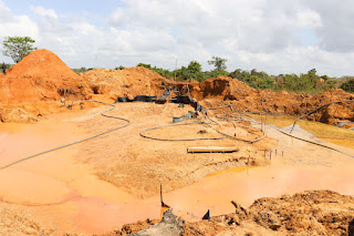
The problem of illegal mining in the Amazon
Mining for materials like gold, copper, iron, and manganese in the Amazon often involves clearing large forest areas and creating mining pits. Gold mining is a reason for 90% of deforestation along the Guiana Shield. Mercury used in gold mining can also contaminate local water sources.
A study by the Amazon Network of Geo-referenced Socio-environmental Information (RAISG) found that illegal mining of gold, diamonds, and columbite-tantalite harms approximately 30 rivers across Bolivia, Colombia, Ecuador, Peru, Venezuela, and Brazil. The study identified more than 4,200 wildcat mining sites in these countries, some in national parks and indigenous lands.
Brazil
Illegal mining is a widespread issue in Brazil, with as many as nine states involved. Illegal mining hotspots in the Amazon Basin include Yanomani and Munduruku areas, both Indigenous reserves. Munduruku's Tapajos basin produced one-third of Brazil's 2018 illegal gold production, totaling around 30 tons.
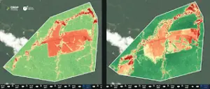
Comparing satellite images from 2017 and 2022, deforestation, illegal mining, and the formation of clearings and roads in one of the mines can be observed. The mining process involves using water, which washes the soil and dumps waste into the Tapajós River.
EOSDA Crop Monitoring platform created by EOS Data Analytics (AI-driven satellite data analytics provider) helped to detect 66 hectares of open land that resulted from logging and its negative consequences. It became possible due to the Normalized Difference Vegetation values calculation available on the all-in-one platform.
Venezuela
The Arco Minero is a mineral-rich area spanning three states. It contains valuable minerals like bauxite, coltan, diamonds, and gold. This biodiverse region borders Canaima National Park, a UNESCO World Heritage Site. Reports indicate mining in prohibited areas, including national parks and protected areas home to indigenous people.
Mining in the area has caused severe environmental damage, including deforestation and high levels of mercury in nearby rivers. These rivers are a crucial source of drinking water and support freshwater fish consumed in Brazil, Guyana, and Trinidad and Tobago. The destruction of the given ecosystem leads to negative consequences for humans, animals, and other species, which is why reforestation is important.
Colombia
Illegal mining in Colombia is rising due to the demand for natural resources and the increasing value of gold. Criminal groups have shifted their focus from cocaine to gold. The UN reports that illegal mining covers over 64,000 hectares of land in 970 known locations.
Chile
The Pascua-Lama mine, on the Chile-Argentina border, extracts copper and gold. The open-pit mining harms the environment and nearby communities by damaging glaciers and polluting water sources used for centuries by locals.
The Pascua-Lama mine in Chile has been ordered to shut down by the country's First Environmental Court after years of legal battles and protests. The decision is seen as a win for environmental advocates, though the Canadian gold-mining company, Barrick, is still exploring the surrounding area for future projects.
The importance of reforestation of the Amazon forest
There are several crucial arguments for restoring forests. Forest ecosystems produce oxygen and retain carbon. They are vital for biodiversity, providing habitats for many unique plant and animal species. They also help with water cycles and soil conservation.
Forests hold cultural and physical significance, serving as resources and homes for indigenous people and holding sacred places for certain ethnic groups—the important heritage can be lost due to deforestation.
Satellites are crucial for monitoring reforestation efforts in the Amazon due to their comprehensive coverage, high-resolution imagery, and real-time data. Managing and monitoring reforestation in remote areas can be simplified using remote sensing technology. The EOSDA Forestry Monitoring solution utilizes satellite data to keep track of reforestation progress. This tool helps environmental organizations and other stakeholders to identify reforestation within a specific area of interest over a required period.
Additional Resources
Sergieieva, K. (2023). "Reforestation: Pros, Cons And Effects On Planet." Available at: https://eos.com/blog/reforestation/.
Tatiana Vasiltsova
Tatiana Vasiltsova is a lifelong eco-activist. Her expertise covers satellite monitoring of natural and man-made landscapes and detection of changes in surface characteristics. Tatyana is a Ph.D. student in information technology and has an impressive list of technical publications.